 | |||||||||
Melbourne, Australia and Vancouver, Canada – January 20, 2026 – TheNewswire - Mithril Silver and Gold Limited ("Mithril” or the "Company") (TSXV: MSG) (ASX: MTH) (OTCQB: MTIRF) is pleased to provide exploration success at Mithril’s district scale Copalquin property, Durango State, Mexico.
-
High-grade in shallow intercepts returned from expansive resource drilling at Target 1 ahead of the Target 1 mineral resource estimation (MRE) update
-
Target 1 drilling highlights include
-
1.55 m @ 2.11 g/t gold, 5.5 g/t silver from 24.65 m (MTH-RE25-54), plus
-
1.35 m @ 21.9 g/t gold, 357 g/t silver from 142.75 m, including
0.50 m @ 57.7 g/t gold, 924 g/t silver from 143.6 m
-
-
3.05 m @ 1.68 g/t gold, 107 g/t silver from 52.0 m (MTH-LS25-53), including
-
0.50 m @ 9.60 g/t gold, 612 g/t silver from 52.0 m, plus
2.80 m @ 2.29 g/t gold, 60.3 g/t silver from 65.25 m, including
0.50 m @ 10.6 g/t gold, 298 g/t silver from 67.55 m, plus
4.40 m @ 2.18 g/t gold, 14.6 g/t silver from 77.2 m
0.50 m @ 15.5 g/t gold, 66.1 g/t silver from 81.1 m
-
Drilling on the western side of Target 1 (150 metre anomalous silver zone intercept in MTH-RE25-58 extends the District east-west mineralised structure 300 metres west plus extensive hydrothermal alteration. This large alteration zone indicates significant hydrothermal fluid flow which possibly represents a major feeder zone in this part of the District. This is further supported by our recent petrographic work (see discussion below). The east-west structure likely extends a further 600 metres west to the El Gallo workings where high-grade gold and silver was intercepted in previous drilling (see ASX announcement date 5 May 2022)1 providing significant scale upside.
-
300 metre down dip extension of the Refugio 1 structure, also on the western side of Target 1 (MTH-RE25-47 and 56), are the deepest intercepts in this area to date which (with the intercept in MTH-RE25-058) provide vectors for continued expansion of the Copalquin District model.
“The recent drilling at Target 1 has successfully expanded the resource potential for the upcoming Target 1 MRE update and provided important success in the development of the larger District scale model”, said John Skeet, Managing Director & CEO.
“The drilling on the western side of Target 1 intersected a broad anomalous silver zone with pervasive hydrothermal alteration associated with the district-scale east–west structure. In low-sulphidation systems, this style of alteration and silver enrichment is indicative of a well-developed hydrothermal conduit or feeder zone and supports further potential for mineralisation along strike and at depth as well as the District bigger picture.
The 300-metre down-dip extension of the Refugio 1 structure confirms vertical continuity of the system and provides clear scope to expand the Target 1 resource beyond the current model.”
Copalquin District - 2026
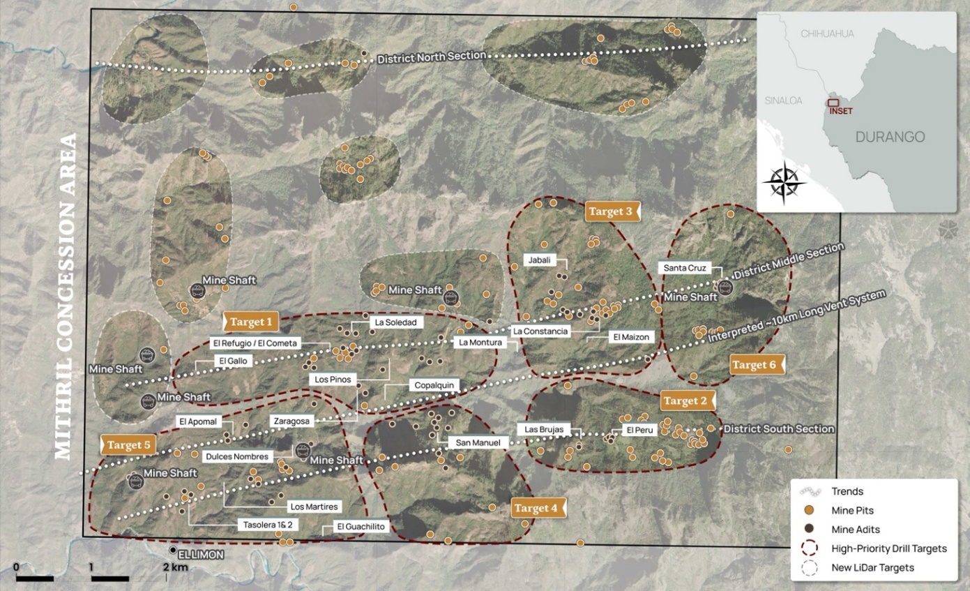
Mithril is undertaking an aggressive exploration program in 2026, with 25,000 metres of drilling planned during the first half of the year across the Copalquin District. Upcoming work will focus on expanding known mineralized zones, testing new high-priority targets, integrating district-wide geophysical data, and continuing to advance the Company’s district-scale exploration thesis. The district features over 100 historic underground workings including several notable producing multi-level mines and 200 surface workings. Mapping and sampling across the lower half of the 70 km2 mining concession area demonstrates and a large epithermal silver-gold system with multiple target areas for potential resource growth plus the conduit system responsible for the widespread silver and gold mineralisation.
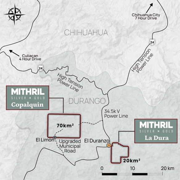
The nearby 20 km2 La Dura property has recently been added to the portfolio providing where a LiDAR survey has been flown (interpretation anticipated in February 2026) and will undergo and aerial magnetic survey upon completion of the aerial magnetic survey at Copalquin commencing in January 2026.
Click Image To View Full Size
Figure 1 Mithril’s Copalquin and La Dura property locations in Durango State, Mexico
Click Image To View Full Size
Figure 2 LiDAR identified historic workings across the 70km2 district. Current drilling locations at Target 1 west and Target 5 (El Apomal), and recent drilling at Zaragoza mine in Target 1 south, high priority drill target area of La Constancia-El Jabali (Target 3). Several new areas highlighted across the district for follow-up work including recently sampled Target 6
Target 1 Drilling Discussion
Drilling continued throughout 2025 at the Target 1 area aiming to expand the maiden resource. The results throughout the year and reported in this announcement have continued to successfully expand the footprint and fill in areas with the objective to bring more tonnes into classification for a mineral resource estimate (MRE) update. Approximately 3,000 metres of drilling is to be completed in Q1 2026 to finalise the drilling for the MRE update. 3D modelling of the updated geology including the post mineral intrusive unit has created a robust and predictable model for the upcoming MRE.
Recently received drill results have intersected very high-grade gold and silver and provided supportive geological control data for the Target 1 model.
Assay highlights include
-
-
1.55 m @ 2.11 g/t gold, 5.5 g/t silver from 24.65 m (MTH-RE25-54), plus
-
1.35 m @ 21.9 g/t gold, 357 g/t silver from 142.75 m, including
0.50 m @ 57.7 g/t gold, 924 g/t silver from 143.6 m
-
-
3.05 m @ 1.68 g/t gold, 107 g/t silver from 52.0 m (MTH-LS25-53), including
-
0.50 m @ 9.60 g/t gold, 612 g/t silver from 52.0 m, plus
2.80 m @ 2.29 g/t gold, 60.3 g/t silver from 65.25 m, including
0.50 m @ 10.6 g/t gold, 298 g/t silver from 67.55 m, plus
4.40 m @ 2.18 g/t gold, 14.6 g/t silver from 77.2 m
0.50 m @ 15.5 g/t gold, 66.1 g/t silver from 81.1 m
Table 1 Interval for results received for Target 1 drilling reported.
|
Hole ID |
From (m) |
To (m) |
Interval (m) |
Au g/t |
Ag g/t |
AuEq g/t |
|
MTH-RE25-46 |
59.5 |
61.2 |
1.7 |
0.59 |
11.1 |
0.75 |
|
MTH-RE25-46 |
65.25 |
69.2 |
3.95 |
1.37 |
22.2 |
1.69 |
|
MTH-RE25-47 |
442.3 |
444.65 |
2.35 |
1.18 |
24.2 |
1.52 |
|
MTH-LS25-52 |
72.7 |
73.2 |
0.5 |
1.11 |
4.4 |
1.17 |
|
MTH-LS25-52 |
264.5 |
266 |
1.5 |
0.39 |
63.6 |
1.30 |
|
MTH-LS25-53 |
44.7 |
45.2 |
0.5 |
2.64 |
42.3 |
3.24 |
|
MTH-LS25-53 |
52 |
55.05 |
3.05 |
1.68 |
107 |
3.20 |
|
including |
52 |
52.5 |
0.5 |
9.60 |
612 |
18.34 |
|
MTH-LS25-53 |
65.25 |
68.05 |
2.80 |
2.29 |
60.3 |
3.15 |
|
including |
67.55 |
68.05 |
0.5 |
10.55 |
298 |
14.81 |
|
MTH-LS25-53 |
77.2 |
81.6 |
4.40 |
2.18 |
14.6 |
2.39 |
|
including |
81.1 |
81.6 |
0.5 |
15.50 |
66.1 |
16.44 |
|
MTH-LS25-53 |
91.7 |
93 |
1.3 |
0.44 |
0.7 |
0.45 |
|
MTH-LS25-53 |
226 |
226.5 |
0.5 |
1.07 |
2.7 |
1.11 |
|
MTH-RE25-54 |
5.50 |
8.30 |
2.80 |
0.27 |
19.7 |
0.56 |
|
MTH-RE25-54 |
12 |
12.65 |
0.65 |
0.60 |
19.1 |
0.87 |
|
MTH-RE25-54 |
18.85 |
20 |
1.15 |
0.31 |
11.0 |
0.47 |
|
MTH-RE25-54 |
24.65 |
26.20 |
1.55 |
2.11 |
5.50 |
2.19 |
|
MTH-RE25-54 |
28.70 |
29.60 |
0.90 |
0.524 |
23.1 |
0.85 |
|
MTH-RE25-54 |
32.25 |
34.85 |
2.60 |
0.30 |
2.40 |
0.33 |
|
MTH-RE25-54 |
133.7 |
135 |
1.30 |
0.72 |
54.7 |
1.50 |
|
MTH-RE25-54 |
142.75 |
144.1 |
1.35 |
21.94 |
357 |
27.04 |
|
including |
143.6 |
144.1 |
0.50 |
57.65 |
924 |
70.85 |
|
MTH-RE25-55 |
No reportable intercepts |
|||||
|
MTH-RE25-56 |
441.75 |
447.2 |
5.45 |
0.78 |
35.9 |
1.29 |
|
including |
441.75 |
442.7 |
0.95 |
1.08 |
39.5 |
1.64 |
|
including |
444.7 |
447.2 |
2.50 |
1.26 |
62.1 |
2.15 |
|
MTH-RE25-57 |
189.15 |
189.65 |
0.50 |
1.43 |
128 |
3.25 |
|
MTH-RE25-58 |
165.85 |
166.35 |
0.50 |
1.09 |
82.2 |
2.26 |
|
MTH-RE25-59 |
No reportable intercepts |
|||||
Click Image To View Full Size
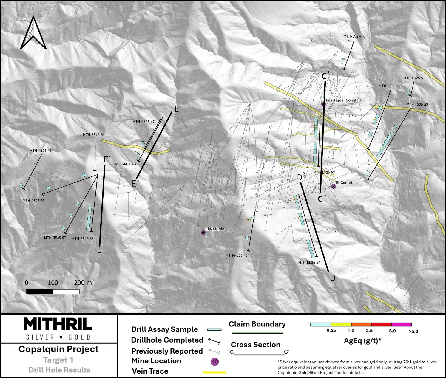
Figure 3 Plan map for the Target 1 drilling reported and section lines for the following cross sections
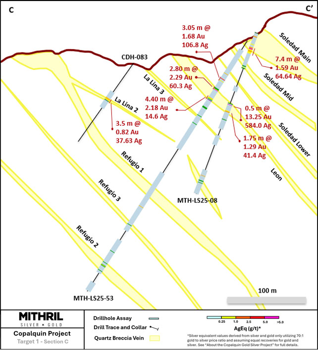
Figure 4 Section C - high-grade intercepts on the eastern side of the Target 1 resource successfully in-filling an area with previously insufficient data in this relatively shallow area.
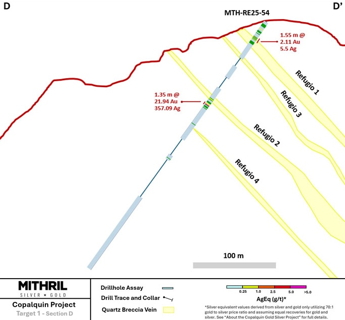
Figure 5 Section D with multiple intercepts including those highlighted on the above section.
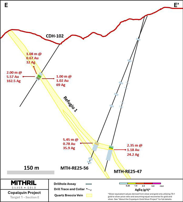
Figure 6 Section E successfully intercepting the Refugio 1 structure on the eastern side over 300 metres down dip
Further Evidence of the Large Hydrothermal System
Drilling on the western end of the resource area at Target 1 has continued to provide further evidence of continuation of the east-west mineralised structure plus extensive hydrothermal alteration.
In a low sulphidation epithermal deposit, the presence of a wide alteration halo combined with silver-rich mineralization is a strong indicator of a robust, long-lived hydrothermal system and has important implications for both scale and exploration potential.
A broad alteration halo reflects extensive circulation of neutral to weakly alkaline hydrothermal fluids through permeable structures and surrounding wall rocks. Alteration assemblages commonly include quartz, adularia, sericite, with variable carbonate, chlorite and locally developed clay alteration. The breadth of alteration indicates that fluid flow was not restricted to narrow vein conduits, but instead affected a large volume of rock, increasing the likelihood of multiple mineralized structures, stacked veins, or locally disseminated mineralization. From an exploration standpoint, wide alteration halos provide large, mappable footprints that can be detected through mapping, geochemistry, and remote sensing, allowing effective vectoring toward higher grade zones.
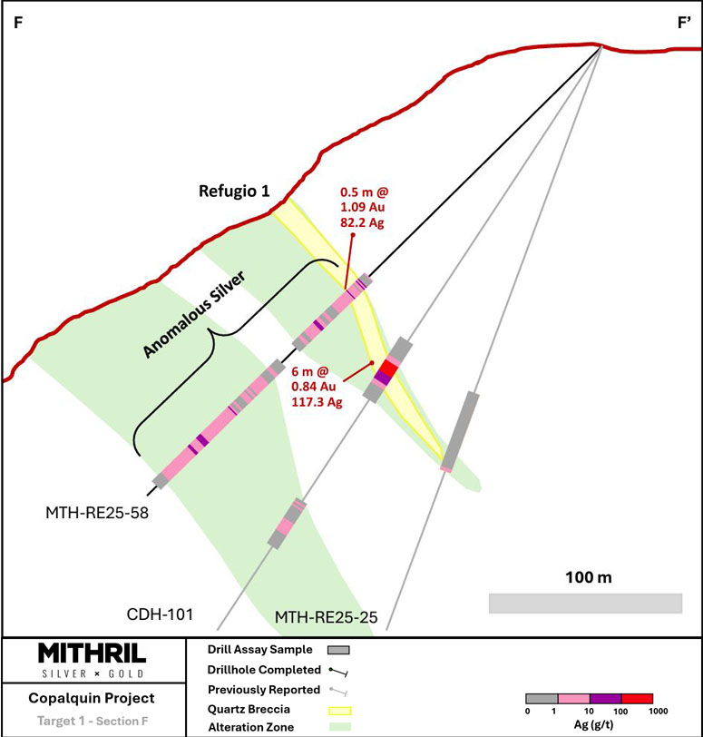
Click Image To View Full Size
Figure 7 Drill hole MTH-RE25-58 intercepted a thick anonymously silver rich alteration halo on the western side of Target 1
Silver mineralization is a characteristic feature of low sulphidation epithermal systems and commonly occurs as electrum, acanthite, native silver, silver sulfosalts, or Ag-bearing base metal sulphides. Elevated silver grades often reflect boiling, fluid mixing, or rapid pressure changes within the epithermal environment, processes that are also efficient at precipitating gold. Silver rich zones may be laterally or vertically offset from gold dominant zones, commonly occupying higher or more distal portions of the system, and therefore provide valuable vectors toward potentially gold rich feeder structures at depth or along strike.
Together, a wide alteration halo and significant silver mineralization suggest a well-developed epithermal system with favourable permeability architecture and strong hydrothermal flux. This combination increases the probability of discovering additional veins, higher grade shoots, or vertically zoned precious metal mineralization, and supports the potential for a district scale mineralized system rather than isolated, narrow veins.
Table 2 Drill hole collar details reported in this announcement
|
Hole ID |
Easting (m) |
Northing (m) |
Elevation (m) |
Azimuth (degrees) |
Inclination (degrees) |
Depth (m) |
|
MTH-RE25-46 |
289355 |
2823700 |
1246.14 |
188 |
-50 |
249 |
|
MTH-RE25-47 |
288996.3 |
2824042 |
1188.21 |
210 |
-75 |
516 |
|
MTH-RE25-48 |
288547 |
2823911 |
1133.83 |
205 |
-65 |
351 |
|
MTH-LS25-49 |
289869 |
2824152 |
1065.27 |
200 |
-45 |
342 |
|
MTH-LS25-50 |
289729 |
2824339 |
1057.79 |
195 |
-73 |
402 |
|
MTH-LS25-51 |
289956 |
2824182 |
1081.41 |
195 |
-65 |
132 |
|
MTH-LS25-52 |
289943 |
2824082 |
1094.17 |
210 |
-45 |
450 |
|
MTH-LS25-53 |
289601 |
2824056 |
1141.2 |
180 |
-55 |
339 |
|
MTH-RE25-54 |
289519 |
2823757 |
1192.72 |
165 |
-55 |
417 |
|
MTH-RE25-55 |
288759 |
2823832 |
1189.26 |
250 |
-50 |
351 |
|
MTH-RE25-56 |
289004 |
2824047 |
1189.1 |
210 |
-69 |
516 |
|
MTH-RE25-57 |
288757 |
2823827 |
1190.94 |
210 |
-45 |
351 |
|
MTH-RE25-58 |
288757 |
2823827 |
1190.94 |
185 |
-45 |
300 |
|
MTH-RE25-59 |
288748 |
2823965 |
1232.44 |
180 |
-77 |
501 |
ABOUT THE COPALQUIN GOLD SILVER PROJECT
The Copalquin mining district is located in Durango State, Mexico and covers an entire mining district of 70km2 containing several dozen historic gold and silver mines and workings, ten of which had notable production. The district is within the Sierra Madre Gold Silver Trend which extends north-south along the western side of Mexico and hosts many gold and silver districts.
Multiple mineralisation events, young intrusives thought to be system-driving heat sources, widespread alteration together with extensive surface vein exposures and dozens of historic mine workings, identify the Copalquin mining district as a major epithermal centre for Gold and Silver.
Within 15 months of drilling in the Copalquin District, Mithril delivered a maiden JORC mineral resource estimate at the first of several target areas (Target 1), demonstrating the high-grade gold and silver resource potential for the district. This maiden resource is detailed below (see ASX release 17 November 2021)^ and a NI 43-101 Technical Report filed on SEDAR+
Target 1 Maiden Resource:
-
Indicated 691 kt @5.43 g/t gold, 114 g/t silver for 121,000 oz gold plus 2,538,000 oz silver
-
Inferred 1,725 kt @4.55 g/t gold, 152 g/t silver for 252,000 oz gold plus 8,414,000 oz silver
(using a cut-off grade of 2.0 g/t AuEq*)
-
28.6% of the resource tonnage is classified as indicated
Table 3 Mineral resource estimate at Target 1 El Refugio – La Soledad using a cut-off grade of 2.0 g/t AuEq*
|
Tonnes (kt) |
Tonnes (kt) |
Gold (g/t) |
Silver (g/t) |
Gold Eq.* (g/t) |
Gold (koz) |
Silver (koz) |
Gold Eq.* (koz) |
|
|
El Refugio |
Indicated |
691 |
5.43 |
114.2 |
7.06 |
121 |
2,538 |
157 |
|
Inferred |
1,447 |
4.63 |
137.1 |
6.59 |
215 |
6,377 |
307 |
|
|
La Soledad |
Indicated |
- |
- |
- |
- |
- |
- |
- |
|
Inferred |
278 |
4.12 |
228.2 |
7.38 |
37 |
2,037 |
66 |
|
|
Total |
Indicated |
691 |
5.43 |
114.2 |
7.06 |
121 |
2,538 |
157 |
|
Inferred |
1,725 |
4.55 |
151.7 |
6.72 |
252 |
8,414 |
372 |
* In determining the gold equivalent (AuEq.) grade for reporting, a gold:silver price ratio of 70:1 was determined, using the formula: AuEq grade = Au grade + ((Ag grade/70) x (Ag recovery/Au recovery)). The metal prices used to determine the 70:1 ratio are the cumulative average prices for 2021: gold USD1,798.34 and silver: USD25.32 (actual is 71:1) from kitco.com.
For silver equivalent (AgEq.) grade reporting, the same factors as above are used with the formula AgEq grade = Ag grade + ((Au grade x 70) x (Au recovery/Ag recovery))
At this early stage, the metallurgical recoveries were assumed to be equal (93%). Subsequent preliminary metallurgical test work produced recoveries of 91% for silver and 96% for gold (ASX Announcement 25 February 2022) and these will be used when the resource is updated in the future. In the Company’s opinion there is reasonable potential for both gold and silver to be extracted and sold.
^ The information in this report that relates to Mineral Resources or Ore Reserves is based on information provided in the following ASX announcement: 17 Nov 2021 - MAIDEN JORC RESOURCE 529,000 OUNCES @ 6.81G/T (AuEq*), which includes the full JORC MRE report, also available on the Mithril Resources Limited Website.
The Company confirms that it is not aware of any new information or data that materially affects the information included in the original market announcement and that all material assumptions and technical parameters underpinning the estimates in the relevant market announcement continue to apply and have not materially changed. The company confirms that the form and context in which the Competent Person’s findings are presented have not been materially modified from the original market announcement.
Mining study (conceptual) and metallurgical test work supports the development of the El Refugio-La Soledad resource with conventional underground mining methods indicated as being appropriate and with high gold-silver recovery to produce metal on-site with conventional processing. The average vein width is approximately 4.5 metres.
Mithril is currently exploring in the Copalquin District to expand the resource footprint, demonstrating its multi-million-ounce gold and silver potential. Mithril has an exclusive option to purchase 100% interest in the Copalquin mining concessions by paying US$10M on or any time before 7 August 2028.
-ENDS-
Released with the authority of the Board.
For further information contact:
|
John Skeet Managing Director and CEO +61 435 766 809 |
NIKLI COMMUNICATIONS Corporate Communications |
The Australian Securities Exchange has not reviewed and does not accept responsibility for the accuracy or adequacy of this release.
Neither TSX Venture Exchange nor its Regulation Services Provider (as that term is defined in policies of the TSX Venture Exchange) accepts responsibility for the adequacy or accuracy of this release.
Competent Persons Statement - JORC
The information in this announcement that relates to metallurgical test results, mineral processing and project development and study work has been compiled by Mr John Skeet who is Mithril’s CEO and Managing Director. Mr Skeet is a Fellow of the Australasian Institute of Mining and Metallurgy. This is a Recognised Professional Organisation (RPO) under the Joint Ore Reserves Committee (JORC) Code.
Mr Skeet has sufficient experience of relevance to the styles of mineralisation and the types of deposits under consideration, and to the activities undertaken, to qualify as a Competent Person as defined in the 2012 Edition of the Joint Ore Reserves Committee (JORC) Australasian Code for Reporting of Exploration Results, Mineral Resources and Ore Reserves. Mr Skeet consents to the inclusion in this report of the matters based on information in the form and context in which it appears. The Australian Securities Exchange has not reviewed and does not accept responsibility for the accuracy or adequacy of this release.
The information in this announcement that relates to sampling techniques and data, exploration results and geological interpretation for Mithril’s Mexican project, has been compiled by Mr Darren LeFort who is Mithril’s Exploration Manager. Mr LeFort is a member of the Engineers and Geoscientists of British Columbia and a Certified Professional Geologist (P.Geo). This is a Recognised Professional Organisation (RPO) under the Joint Ore Reserves Committee (JORC) Code.
Mr LeFort has sufficient experience of relevance to the styles of mineralisation and the types of deposits under consideration, and to the activities undertaken, to qualify as a Competent Person as defined in the 2012 Edition of the Joint Ore Reserves Committee (JORC) Australasian Code for Reporting of Exploration Results, Mineral Resources and Ore Reserves. Mr LeFort consents to the inclusion in this report of the matters based on information in the form and context in which it appears.
The information in this announcement that relates to Mineral Resources is reported by Mr Rodney Webster, former Principal Geologist at AMC Consultants Pty Ltd (AMC), who is a Member of the Australian Institute of Geoscientists. The report was peer reviewed by Andrew Proudman, Principal Consultant at AMC. Mr Webster is acting as the Competent Person, as defined in the 2012 Edition of the Joint Ore Reserves Committee (JORC) Australasian Code for Reporting of Exploration Results, Mineral Resources and Ore Reserves, for the reporting of the Mineral Resource estimate. A site visit was carried out by Jose Olmedo a geological consultant with AMC, in September 2021 to observe the drilling, logging, sampling and assay database. Mr Webster consents to the inclusion in this report of the matters based on information in the form and context in which it appears
Qualified Persons – NI 43-101
Scientific and technical information in this Report has been reviewed and approved by Mr John Skeet (FAUSIMM, CP) Mithril’s Managing Director and Chief Executive Officer. Mr John Skeet is a qualified person within the meaning of NI 43-101.
Samples are sent to ALS Global with sample preparation performed in Chihuahua City, Mexico and assaying of sample pulps performed in North Vancouver, BC, Canada
Table 4 All drill results reported greater than or equal to 0.1 g/t AuEq
|
Drillhole ID |
Sample ID |
From (m) |
To (m) |
Au g/t |
Ag g/t |
AuEq g/t |
Cu g/t |
Pb g/t |
Zn g/t |
|
MTH-RE25-46 |
821441 |
59.5 |
60.6 |
0.451 |
10.8 |
0.61 |
55 |
7 |
89 |
|
MTH-RE25-46 |
821442 |
60.6 |
61.2 |
0.858 |
11.7 |
1.03 |
56 |
7 |
90 |
|
MTH-RE25-46 |
821446 |
64.55 |
65.25 |
0.073 |
5.6 |
0.15 |
47 |
75 |
122 |
|
MTH-RE25-46 |
821447 |
65.25 |
65.8 |
1.925 |
46.5 |
2.59 |
46 |
25 |
84 |
|
MTH-RE25-46 |
821448 |
65.8 |
66.45 |
0.45 |
8.8 |
0.58 |
34 |
9 |
49 |
|
MTH-RE25-46 |
821449 |
66.45 |
67 |
3.65 |
45.3 |
4.30 |
44 |
26 |
65 |
|
MTH-RE25-46 |
821451 |
67 |
67.8 |
1.31 |
20.8 |
1.61 |
34 |
31 |
108 |
|
MTH-RE25-46 |
821452 |
67.8 |
68.4 |
1.285 |
16.9 |
1.53 |
32 |
21 |
77 |
|
MTH-RE25-46 |
821453 |
68.4 |
69.2 |
0.313 |
6 |
0.40 |
27 |
17 |
77 |
|
MTH-RE25-47 |
821494 |
436 |
436.7 |
0.08 |
10.4 |
0.23 |
60 |
73 |
305 |
|
MTH-RE25-47 |
821495 |
436.7 |
438 |
0.192 |
30.8 |
0.63 |
26 |
78 |
139 |
|
MTH-RE25-47 |
821499 |
440 |
441 |
0.351 |
32.2 |
0.81 |
98 |
279 |
343 |
|
MTH-RE25-47 |
821501 |
441 |
441.6 |
0.232 |
5.9 |
0.32 |
39 |
101 |
112 |
|
MTH-RE25-47 |
821503 |
441.6 |
442.3 |
0.378 |
7.3 |
0.48 |
124 |
696 |
700 |
|
MTH-RE25-47 |
821504 |
442.3 |
442.9 |
1.605 |
57.4 |
2.43 |
150 |
1005 |
2260 |
|
MTH-RE25-47 |
821505 |
442.9 |
443.5 |
0.836 |
14.8 |
1.05 |
241 |
1050 |
3380 |
|
MTH-RE25-47 |
821506 |
443.5 |
444 |
0.576 |
10.2 |
0.72 |
228 |
1060 |
4430 |
|
MTH-RE25-47 |
821507 |
444 |
444.65 |
1.555 |
12.9 |
1.74 |
297 |
282 |
1585 |
|
MTH-RE25-48 |
821559 |
341 |
343 |
0.042 |
5.5 |
0.12 |
390 |
244 |
232 |
|
MTH-RE25-48 |
821563 |
345.8 |
347 |
0.165 |
1.4 |
0.19 |
39 |
44 |
82 |
|
MTH-LS25-49 |
821570 |
101.05 |
101.95 |
0.63 |
18.6 |
0.90 |
24 |
365 |
18 |
|
MTH-LS25-49 |
821606 |
163 |
163.65 |
0.067 |
3.2 |
0.11 |
7 |
6 |
12 |
|
MTH-LS25-49 |
821624 |
178.4 |
178.9 |
0.704 |
1.4 |
0.72 |
35 |
698 |
1190 |
|
MTH-LS25-49 |
821626 |
178.9 |
179.5 |
0.379 |
1.9 |
0.41 |
13 |
66 |
73 |
|
MTH-LS25-49 |
821627 |
179.5 |
180 |
0.143 |
2.9 |
0.18 |
57 |
457 |
1745 |
|
MTH-LS25-49 |
821628 |
180 |
180.5 |
0.203 |
3.6 |
0.25 |
168 |
1515 |
439 |
|
MTH-LS25-49 |
821629 |
180.5 |
181.25 |
0.475 |
4 |
0.53 |
100 |
648 |
725 |
|
MTH-LS25-49 |
821632 |
182.75 |
183.7 |
0.817 |
3.2 |
0.86 |
5 |
11 |
55 |
|
MTH-LS25-49 |
821641 |
191.45 |
192 |
0.091 |
2 |
0.12 |
5 |
52 |
96 |
|
MTH-LS25-50 |
821713 |
267.25 |
267.85 |
0.091 |
7.4 |
0.20 |
31 |
29 |
55 |
|
MTH-LS25-50 |
821726 |
280.25 |
280.95 |
0.07 |
12 |
0.24 |
13 |
44 |
75 |
|
MTH-LS25-50 |
821727 |
280.95 |
282.05 |
0.112 |
24.4 |
0.46 |
51 |
38 |
93 |
|
MTH-LS25-51 |
821756 |
91.5 |
92 |
0.185 |
1.5 |
0.21 |
26 |
21 |
63 |
|
MTH-LS25-52 |
821783 |
14.3 |
14.95 |
0.031 |
5.2 |
0.11 |
31 |
27 |
53 |
|
MTH-LS25-52 |
821790 |
72.7 |
73.2 |
1.105 |
4.4 |
1.17 |
22 |
19 |
63 |
|
MTH-LS25-52 |
821794 |
125.2 |
125.95 |
0.089 |
0.8 |
0.10 |
15 |
12 |
53 |
|
MTH-LS25-52 |
821829 |
193 |
193.5 |
0.087 |
11 |
0.24 |
15 |
37 |
32 |
|
MTH-LS25-52 |
821838 |
203.4 |
204.3 |
0.089 |
4.3 |
0.15 |
15 |
16 |
68 |
|
MTH-LS25-52 |
821847 |
216 |
217.1 |
0.044 |
5.1 |
0.12 |
5 |
7 |
27 |
|
MTH-LS25-52 |
821882 |
253.15 |
254.05 |
0.052 |
3.7 |
0.10 |
25 |
16 |
124 |
|
MTH-LS25-52 |
821887 |
258.4 |
259.4 |
0.097 |
2.3 |
0.13 |
111 |
162 |
267 |
|
MTH-LS25-52 |
821893 |
264.5 |
266 |
0.389 |
63.6 |
1.30 |
79 |
146 |
105 |
|
MTH-LS25-53 |
821961 |
14 |
15 |
0.08 |
5.1 |
0.15 |
27 |
5 |
90 |
|
MTH-LS25-53 |
821967 |
20 |
21 |
0.029 |
5.2 |
0.10 |
46 |
53 |
103 |
|
MTH-LS25-53 |
821972 |
25.85 |
26.35 |
0.069 |
8.7 |
0.19 |
54 |
53 |
108 |
|
MTH-LS25-53 |
821974 |
27 |
28 |
0.045 |
5.8 |
0.13 |
58 |
39 |
136 |
|
MTH-LS25-53 |
821989 |
42 |
43 |
0.061 |
7.8 |
0.17 |
56 |
26 |
124 |
|
MTH-LS25-53 |
821992 |
44.7 |
45.2 |
2.64 |
42.3 |
3.24 |
65 |
27 |
85 |
|
MTH-LS25-53 |
822001 |
52 |
52.5 |
9.6 |
612 |
18.34 |
134 |
181 |
295 |
|
MTH-LS25-53 |
822002 |
52.5 |
53.45 |
0.038 |
7.8 |
0.15 |
15 |
38 |
134 |
|
MTH-LS25-53 |
822004 |
54.55 |
55.05 |
0.527 |
14.1 |
0.73 |
9 |
30 |
133 |
|
MTH-LS25-53 |
822015 |
65.25 |
66.4 |
0.49 |
0.6 |
0.50 |
40 |
7 |
99 |
|
MTH-LS25-53 |
822016 |
66.4 |
67.05 |
0.334 |
8.6 |
0.46 |
11 |
68 |
93 |
|
MTH-LS25-53 |
822017 |
67.05 |
67.55 |
0.69 |
27 |
1.08 |
9 |
17 |
14 |
|
MTH-LS25-53 |
822018 |
67.55 |
68.05 |
10.55 |
298 |
14.81 |
23 |
113 |
159 |
|
MTH-LS25-53 |
822030 |
77.2 |
77.75 |
1.305 |
25.9 |
1.68 |
34 |
73 |
180 |
|
MTH-LS25-53 |
822031 |
77.75 |
78.8 |
0.566 |
3.1 |
0.61 |
32 |
28 |
176 |
|
MTH-LS25-53 |
822032 |
78.8 |
79.8 |
0.169 |
3.4 |
0.22 |
31 |
31 |
127 |
|
MTH-LS25-53 |
822034 |
80.35 |
81.1 |
0.437 |
11.2 |
0.60 |
15 |
18 |
42 |
|
MTH-LS25-53 |
822035 |
81.1 |
81.6 |
15.5 |
66.1 |
16.44 |
33 |
109 |
135 |
|
MTH-LS25-53 |
822038 |
82.85 |
83.95 |
0.059 |
3.7 |
0.11 |
15 |
15 |
103 |
|
MTH-LS25-53 |
822048 |
91.7 |
93 |
0.443 |
0.7 |
0.45 |
24 |
38 |
109 |
|
MTH-LS25-53 |
822059 |
102.3 |
102.85 |
0.366 |
3.1 |
0.41 |
40 |
26 |
27 |
|
MTH-LS25-53 |
822069 |
112.5 |
113.1 |
0.229 |
3 |
0.27 |
16 |
17 |
54 |
|
MTH-LS25-53 |
822083 |
131.4 |
132.8 |
0.093 |
2.6 |
0.13 |
8 |
21 |
127 |
|
MTH-LS25-53 |
822087 |
137.1 |
138.5 |
0.099 |
1.3 |
0.12 |
6 |
27 |
97 |
|
MTH-LS25-53 |
840036 |
226 |
226.5 |
1.07 |
2.7 |
1.11 |
59 |
99 |
137 |
|
MTH-LS25-53 |
840069 |
250.75 |
251.35 |
0.125 |
1.1 |
0.14 |
25 |
11 |
69 |
|
MTH-LS25-53 |
840101 |
284.75 |
286 |
0.042 |
7.7 |
0.15 |
14 |
52 |
15 |
|
MTH-LS25-53 |
840103 |
286.75 |
287.25 |
0.103 |
7.5 |
0.21 |
6 |
21 |
157 |
|
MTH-LS25-53 |
840115 |
296 |
296.6 |
0.095 |
1.4 |
0.12 |
3 |
12 |
18 |
|
MTH-LS25-53 |
840119 |
298.55 |
299.7 |
0.08 |
12.1 |
0.25 |
787 |
588 |
301 |
|
MTH-LS25-53 |
840121 |
299.7 |
300.85 |
0.06 |
4.5 |
0.12 |
176 |
121 |
129 |
|
MTH-LS25-53 |
840124 |
301.65 |
302.35 |
0.114 |
0.8 |
0.13 |
2 |
9 |
25 |
|
MTH-LS25-53 |
840130 |
305 |
305.8 |
0.228 |
3.9 |
0.28 |
27 |
39 |
78 |
|
MTH-LS25-53 |
840131 |
305.8 |
306.3 |
0.705 |
2.2 |
0.74 |
19 |
21 |
57 |
|
MTH-LS25-53 |
840132 |
306.3 |
307.15 |
0.296 |
2.6 |
0.33 |
24 |
46 |
82 |
|
MTH-LS25-53 |
840133 |
307.15 |
307.8 |
0.07 |
5.5 |
0.15 |
78 |
523 |
363 |
|
MTH-LS25-53 |
840134 |
307.8 |
308.95 |
0.068 |
5.7 |
0.15 |
19 |
66 |
64 |
|
MTH-LS25-53 |
840139 |
312.05 |
312.75 |
0.168 |
1.8 |
0.19 |
16 |
72 |
89 |
|
MTH-LS25-53 |
840153 |
336.25 |
337.3 |
0.088 |
0.9 |
0.10 |
44 |
54 |
194 |
|
MTH-LS25-53 |
840154 |
337.3 |
338.35 |
0.095 |
0.8 |
0.11 |
54 |
47 |
191 |
|
MTH-RE25-54 |
840156 |
1 |
3.95 |
0.093 |
3.1 |
0.14 |
14 |
16 |
25 |
|
MTH-RE25-54 |
840157 |
3.95 |
5.5 |
0.113 |
10.4 |
0.26 |
24 |
21 |
20 |
|
MTH-RE25-54 |
840158 |
5.5 |
6.4 |
0.205 |
13 |
0.39 |
28 |
21 |
15 |
|
MTH-RE25-54 |
840159 |
6.4 |
7.45 |
0.311 |
24.5 |
0.66 |
15 |
21 |
19 |
|
MTH-RE25-54 |
840161 |
7.45 |
8.3 |
0.303 |
21 |
0.60 |
17 |
33 |
23 |
|
MTH-RE25-54 |
840163 |
9.25 |
9.8 |
0.098 |
6.6 |
0.19 |
25 |
26 |
120 |
|
MTH-RE25-54 |
840165 |
10.3 |
11.1 |
0.051 |
4 |
0.11 |
20 |
19 |
52 |
|
MTH-RE25-54 |
840166 |
11.1 |
12 |
0.075 |
4.6 |
0.14 |
24 |
13 |
108 |
|
MTH-RE25-54 |
840167 |
12 |
12.65 |
0.598 |
19.1 |
0.87 |
33 |
75 |
140 |
|
MTH-RE25-54 |
840171 |
15.1 |
16.35 |
0.113 |
7.4 |
0.22 |
22 |
21 |
95 |
|
MTH-RE25-54 |
840172 |
16.35 |
17.6 |
0.115 |
6.4 |
0.21 |
23 |
40 |
96 |
|
MTH-RE25-54 |
840174 |
18.2 |
18.85 |
0.053 |
4.4 |
0.12 |
29 |
19 |
98 |
|
MTH-RE25-54 |
840176 |
18.85 |
20 |
0.31 |
11 |
0.47 |
29 |
12 |
91 |
|
MTH-RE25-54 |
840181 |
23 |
24 |
0.087 |
4 |
0.14 |
31 |
12 |
82 |
|
MTH-RE25-54 |
840183 |
24.65 |
25.4 |
0.319 |
4 |
0.38 |
43 |
12 |
85 |
|
MTH-RE25-54 |
840184 |
25.4 |
26.2 |
3.79 |
6.9 |
3.89 |
53 |
19 |
109 |
|
MTH-RE25-54 |
840185 |
26.2 |
27 |
0.119 |
4.4 |
0.18 |
52 |
26 |
137 |
|
MTH-RE25-54 |
840187 |
27.75 |
28.7 |
0.123 |
5.2 |
0.20 |
50 |
28 |
132 |
|
MTH-RE25-54 |
840188 |
28.7 |
29.6 |
0.524 |
23.1 |
0.85 |
16 |
75 |
111 |
|
MTH-RE25-54 |
840189 |
29.6 |
30.1 |
0.146 |
3.7 |
0.20 |
28 |
20 |
101 |
|
MTH-RE25-54 |
840190 |
30.1 |
31.3 |
0.069 |
2.6 |
0.11 |
8 |
10 |
46 |
|
MTH-RE25-54 |
840192 |
32.25 |
33.6 |
0.221 |
2.3 |
0.25 |
7 |
13 |
62 |
|
MTH-RE25-54 |
840193 |
33.6 |
34.85 |
0.377 |
2.5 |
0.41 |
18 |
13 |
127 |
|
MTH-RE25-54 |
840194 |
34.85 |
36.05 |
0.172 |
2 |
0.20 |
12 |
12 |
110 |
|
MTH-RE25-54 |
840257 |
131.65 |
132.4 |
0.075 |
3.6 |
0.13 |
10 |
28 |
35 |
|
MTH-RE25-54 |
840258 |
132.4 |
133.2 |
0.097 |
10.3 |
0.24 |
3 |
36 |
27 |
|
MTH-RE25-54 |
840259 |
133.2 |
133.7 |
0.137 |
10.6 |
0.29 |
4 |
16 |
93 |
|
MTH-RE25-54 |
840260 |
133.7 |
134.35 |
0.86 |
78 |
1.97 |
8 |
19 |
42 |
|
MTH-RE25-54 |
840261 |
134.35 |
135 |
0.574 |
31.4 |
1.02 |
4 |
8 |
37 |
|
MTH-RE25-54 |
840262 |
135 |
135.55 |
0.117 |
2.6 |
0.15 |
5 |
29 |
63 |
|
MTH-RE25-54 |
840263 |
135.55 |
137 |
0.091 |
2.9 |
0.13 |
4 |
23 |
54 |
|
MTH-RE25-54 |
840264 |
137 |
139 |
0.086 |
3.7 |
0.14 |
5 |
26 |
57 |
|
MTH-RE25-54 |
840265 |
139 |
140.3 |
0.115 |
3.5 |
0.17 |
7 |
26 |
60 |
|
MTH-RE25-54 |
840266 |
140.3 |
141.55 |
0.106 |
3.3 |
0.15 |
97 |
12 |
128 |
|
MTH-RE25-54 |
840267 |
141.55 |
142.75 |
0.073 |
4.6 |
0.14 |
59 |
10 |
87 |
|
MTH-RE25-54 |
840268 |
142.75 |
143.6 |
0.933 |
23.9 |
1.27 |
4 |
14 |
68 |
|
MTH-RE25-54 |
840269 |
143.6 |
144.1 |
58.4 |
947 |
71.93 |
41 |
70 |
148 |
|
MTH-RE25-54 |
840271 |
144.1 |
144.6 |
0.362 |
10.7 |
0.51 |
3 |
18 |
96 |
|
MTH-RE25-54 |
840272 |
144.6 |
146 |
0.099 |
1.7 |
0.12 |
2 |
16 |
78 |
|
MTH-RE25-54 |
840273 |
146 |
148 |
0.24 |
2.4 |
0.27 |
2 |
16 |
61 |
|
MTH-RE25-54 |
840274 |
148 |
149.4 |
0.071 |
3.4 |
0.12 |
2 |
16 |
96 |
|
MTH-RE25-54 |
840276 |
149.4 |
150.25 |
0.316 |
19.7 |
0.60 |
3 |
14 |
45 |
|
MTH-RE25-54 |
840277 |
150.25 |
150.9 |
0.085 |
5.1 |
0.16 |
3 |
17 |
43 |
|
MTH-RE25-54 |
840281 |
152 |
152.8 |
0.079 |
2 |
0.11 |
4 |
15 |
73 |
|
MTH-RE25-54 |
840298 |
175.25 |
175.75 |
0.19 |
1.2 |
0.21 |
8 |
29 |
59 |
|
MTH-RE25-54 |
840309 |
182 |
182.85 |
0.022 |
7.4 |
0.13 |
10 |
92 |
176 |
|
MTH-RE25-54 |
840311 |
183.75 |
184.35 |
0.056 |
3.4 |
0.10 |
3 |
31 |
91 |
|
MTH-RE25-54 |
840336 |
230.45 |
231.35 |
0.113 |
6.2 |
0.20 |
83 |
45 |
49 |
|
MTH-RE25-54 |
840369 |
328.75 |
329.65 |
0.091 |
36.3 |
0.61 |
44 |
220 |
221 |
|
MTH-RE25-54 |
840370 |
329.65 |
330.65 |
0.031 |
11.9 |
0.20 |
29 |
714 |
336 |
|
MTH-RE25-54 |
840378 |
335.15 |
335.7 |
0.011 |
6.6 |
0.11 |
31 |
155 |
335 |
|
MTH-RE25-54 |
840393 |
346.5 |
347.55 |
0.026 |
22.4 |
0.35 |
26 |
234 |
132 |
|
MTH-RE25-54 |
840394 |
347.55 |
348.35 |
0.025 |
7 |
0.13 |
40 |
257 |
132 |
|
MTH-RE25-56 |
840528 |
441.75 |
442.7 |
1.08 |
39.5 |
1.64 |
36 |
32 |
69 |
|
MTH-RE25-56 |
840531 |
444.7 |
445.7 |
1.11 |
9.6 |
1.25 |
253 |
843 |
1010 |
|
MTH-RE25-56 |
840532 |
445.7 |
446.2 |
1.305 |
110 |
2.88 |
1130 |
3490 |
3880 |
|
MTH-RE25-56 |
840533 |
446.2 |
446.7 |
1.2 |
90.4 |
2.49 |
174 |
1360 |
1570 |
|
MTH-RE25-56 |
840534 |
446.7 |
447.2 |
1.59 |
91 |
2.89 |
215 |
1045 |
1755 |
|
MTH-RE25-56 |
840546 |
456.5 |
457.5 |
0.084 |
2.3 |
0.12 |
21 |
16 |
118 |
|
MTH-RE25-57 |
840577 |
177.7 |
179 |
0.031 |
10.1 |
0.18 |
5 |
15 |
52 |
|
MTH-RE25-57 |
840578 |
179 |
180 |
0.044 |
5.1 |
0.12 |
4 |
20 |
46 |
|
MTH-RE25-57 |
840590 |
189.15 |
189.65 |
1.425 |
128 |
3.25 |
45 |
25 |
112 |
|
MTH-RE25-57 |
840593 |
247.85 |
249 |
0.055 |
5.2 |
0.13 |
4 |
13 |
43 |
|
MTH-RE25-57 |
840597 |
252.3 |
253.05 |
0.188 |
2.9 |
0.23 |
12 |
116 |
302 |
|
MTH-RE25-57 |
840605 |
259 |
261 |
0.021 |
7.8 |
0.13 |
9 |
50 |
98 |
|
MTH-RE25-57 |
840613 |
334.9 |
335.95 |
0.574 |
1.6 |
0.60 |
3 |
10 |
68 |
|
MTH-RE25-58 |
840626 |
158.2 |
158.75 |
0.287 |
13.4 |
0.48 |
12 |
21 |
93 |
|
MTH-RE25-58 |
840627 |
158.75 |
159.55 |
0.104 |
4.3 |
0.17 |
12 |
20 |
62 |
|
MTH-RE25-58 |
840628 |
159.55 |
160.3 |
0.351 |
19 |
0.62 |
13 |
12 |
90 |
|
MTH-RE25-58 |
840629 |
160.3 |
161.45 |
0.082 |
9.6 |
0.22 |
2 |
9 |
105 |
|
MTH-RE25-58 |
840632 |
162 |
162.5 |
0.044 |
6.6 |
0.14 |
41 |
23 |
87 |
|
MTH-RE25-58 |
840634 |
163.3 |
164.15 |
0.094 |
2.7 |
0.13 |
6 |
12 |
120 |
|
MTH-RE25-58 |
840635 |
164.15 |
164.95 |
0.089 |
6.2 |
0.18 |
4 |
11 |
125 |
|
MTH-RE25-58 |
840636 |
164.95 |
165.85 |
0.069 |
2.3 |
0.10 |
7 |
11 |
103 |
|
MTH-RE25-58 |
840637 |
165.85 |
166.35 |
1.085 |
82.2 |
2.26 |
16 |
23 |
101 |
|
MTH-RE25-58 |
840638 |
166.35 |
167 |
0.044 |
5.3 |
0.12 |
3 |
10 |
99 |
|
MTH-RE25-58 |
840639 |
167 |
168 |
0.093 |
8.8 |
0.22 |
24 |
19 |
98 |
|
MTH-RE25-58 |
840642 |
169.55 |
171 |
0.062 |
3.5 |
0.11 |
3 |
16 |
122 |
|
MTH-RE25-58 |
840645 |
174.85 |
176 |
0.224 |
7.3 |
0.33 |
49 |
30 |
160 |
|
MTH-RE25-58 |
840651 |
184 |
186 |
0.152 |
5.3 |
0.23 |
1 |
14 |
83 |
|
MTH-RE25-58 |
840652 |
186 |
188 |
0.478 |
15.1 |
0.69 |
13 |
24 |
92 |
|
MTH-RE25-58 |
840655 |
192 |
194 |
0.178 |
4.2 |
0.24 |
5 |
12 |
77 |
|
MTH-RE25-58 |
840657 |
196 |
197.5 |
0.085 |
1.2 |
0.10 |
26 |
9 |
49 |
|
MTH-RE25-58 |
840671 |
224.3 |
225.1 |
0.084 |
5 |
0.16 |
148 |
47 |
69 |
|
MTH-RE25-58 |
840689 |
243.4 |
244.05 |
0.102 |
13.5 |
0.29 |
21 |
31 |
70 |
|
MTH-RE25-58 |
840697 |
250.5 |
251.35 |
0.07 |
5.8 |
0.15 |
50 |
19 |
124 |
|
MTH-RE25-58 |
840710 |
262.1 |
262.9 |
0.038 |
10.1 |
0.18 |
36 |
45 |
99 |
|
MTH-RE25-58 |
840711 |
262.9 |
263.7 |
0.051 |
14.8 |
0.26 |
21 |
43 |
40 |
|
MTH-RE25-58 |
840712 |
263.7 |
264.9 |
0.03 |
10.3 |
0.18 |
10 |
32 |
25 |
|
MTH-RE25-58 |
840716 |
268.5 |
269.2 |
0.206 |
7.6 |
0.31 |
27 |
39 |
106 |
|
MTH-RE25-58 |
840717 |
269.2 |
270.25 |
0.2 |
15.8 |
0.43 |
62 |
187 |
408 |
|
MTH-RE25-58 |
840727 |
280.7 |
282.1 |
0.073 |
3 |
0.12 |
24 |
19 |
148 |
|
MTH-RE25-58 |
840729 |
283.55 |
285.1 |
0.093 |
5.4 |
0.17 |
79 |
108 |
227 |
|
MTH-RE25-58 |
840730 |
285.1 |
285.6 |
0.059 |
3.3 |
0.11 |
6 |
21 |
69 |
|
MTH-RE25-58 |
840731 |
285.6 |
286.35 |
0.084 |
3.3 |
0.13 |
4 |
21 |
23 |
|
MTH-RE25-58 |
840732 |
286.35 |
287.55 |
0.181 |
5 |
0.25 |
41 |
58 |
240 |
|
MTH-RE25-59 |
840796 |
417.9 |
418.85 |
0.031 |
5.7 |
0.11 |
9 |
7 |
7 |
|
MTH-RE25-59 |
840797 |
418.85 |
419.8 |
0.031 |
6.7 |
0.13 |
7 |
7 |
20 |
|
MTH-RE25-59 |
840842 |
455 |
457.6 |
0.013 |
14.6 |
0.22 |
68 |
14 |
14 |
JORC Code, 2012 Edition – Table 1
Section 1 Sampling Techniques and Data
|
Criteria |
JORC Code explanation |
Commentary |
|
Sampling techniques |
|
|
|
Drilling techniques |
|
|
|
Drill sample recovery |
|
|
|
Logging |
|
|
|
Sub-sampling techniques and sample preparation |
|
|
|
Quality of assay data and laboratory tests |
|
|
|
Verification of sampling and assaying |
|
|
|
Location of data points |
|
|
|
Data spacing and distribution |
|
|
|
Orientation of data in relation to geological structure |
|
|
|
Sample security |
|
|
|
Audits or reviews |
|
|
Section 2 Reporting of Exploration Results
|
Criteria |
JORC Code explanation |
Commentary |
||||||||||||||||||||||||||||||||||||||||||||||||||||||||||||||||||||||||||||||||||||||||||||||||||||||||||||||
|
Mineral tenement and land tenure status |
|
|
||||||||||||||||||||||||||||||||||||||||||||||||||||||||||||||||||||||||||||||||||||||||||||||||||||||||||||||
|
Exploration done by other parties |
|
|
||||||||||||||||||||||||||||||||||||||||||||||||||||||||||||||||||||||||||||||||||||||||||||||||||||||||||||||
|
Geology |
|
|
||||||||||||||||||||||||||||||||||||||||||||||||||||||||||||||||||||||||||||||||||||||||||||||||||||||||||||||
|
Drill hole Information |
|
See Table 2 in the announcement. |
||||||||||||||||||||||||||||||||||||||||||||||||||||||||||||||||||||||||||||||||||||||||||||||||||||||||||||||
|
Data aggregation methods |
|
|
||||||||||||||||||||||||||||||||||||||||||||||||||||||||||||||||||||||||||||||||||||||||||||||||||||||||||||||
|
Relationship between mineralisation widths and intercept lengths |
|
|
||||||||||||||||||||||||||||||||||||||||||||||||||||||||||||||||||||||||||||||||||||||||||||||||||||||||||||||
|
Diagrams |
|
See figures in announcement |
||||||||||||||||||||||||||||||||||||||||||||||||||||||||||||||||||||||||||||||||||||||||||||||||||||||||||||||
|
Balanced reporting |
|
|
||||||||||||||||||||||||||||||||||||||||||||||||||||||||||||||||||||||||||||||||||||||||||||||||||||||||||||||
|
Other substantive exploration data |
|
|
||||||||||||||||||||||||||||||||||||||||||||||||||||||||||||||||||||||||||||||||||||||||||||||||||||||||||||||
|
Further work |
|
|
1 ASX announcement EXPLORATION CONTINUES TO EXPAND, COPALQUIN DISTRICT, MEXICO, 5 May 2022
Copyright (c) 2026 TheNewswire - All rights reserved.